
Spatially Aware Multi-Modal Directional Radiation Detector Swarms
Project # 23-114 | Year 2 of 3
James Essex, Bryan Lubay, Martin Arguelles-Perez, Ryan Jensen, Eric Schmidthuber, William Edwards
Remote Sensing Lab- Nellis (RSLN)
This work was done by Mission Support and Test Services, LLC, under Contract No. DE-NA0003624 with the U.S. Department of Energy, the NNSA Office of Defense Programs, and supported by the Site-Directed Research and Development Program. DOE/NV/03624–1919.
Abstract
This project is exploring spatially aware platforms that combine inputs from multiple sensors to estimate detector measurement locations. Spatial awareness along with enabling protocols for radiation data exchanged between sensors will allow for the application of more robust methods for source detection and localization.
Background
All existing radiation detection systems utilize alarming algorithms that are temporal, and the localization of a potential threat currently requires manual methods and operator skill. If alerted using existing systems, the operator can rotate using body shielding to affect count rate or use a finder mode with tones that increase as the count rate increases. In access‐restricted environments, it is not currently possible to locate a source without long dwells using sophisticated and expensive instrumentation. These methods are slow and error‐prone, require post‐processing, or, in some tactical situations, are not practical or safe.
Technical Approach
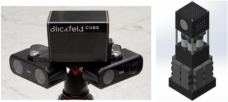
In the first year of this effort, we tested spatial sensing capabilities and developed the software layer to map relative positions of devices into a common local coordinate system. Our approach to this effort will be to utilize similar methods to those used with the HoloLens (Essex et al. 2018), but we will adapt the spatial sensing to the new Inertial Measurement Unit, RGB-Depth camera-based Simultaneous Localization and Mapping, Light Detection and Ranging (LIDAR), and Ultra-Wide Band modules with new modular gamma and neutron detectors.
Results and Technical Accomplishments
In the second year of this effort, we continued to optimize pedestrian-based spatial awareness technologies and completed a directional detection system, firmware, and data consumption via an Android mobile device. We added a second RGB-Depth camera for a wider field of view and co-registered a LIDAR system within the Simultaneous Localization and Mapping (SLAM) software environment. Several data collection campaigns were executed in a variety of environments that represent the spectrum of operational conditions of interest. These tests enable characterization of the performance of the spatial awareness suite.
Conclusions and Path Forward
This effort is novel because all previous radiation anomaly detection efforts have focused solely on temporal detector response and have not been capable of exploiting precise spatial coordinates of each measurement or angular indications from a multi‐detector system. In addition to increasing the sensitivity of anomaly detection, we will develop algorithms for determining optimal data for incorporation into existing localization algorithms.
The development of this technology represents: 1) a practical solution to mapping radiation measurements in GPS-denied environments, and 2) the potential to equip current overt radiological search teams with a capability to localize a radiation source. This could enable the discovery of potential threat sources in rooms or buildings without access, such as apartment complexes, office spaces, or high‐rises, and reduce the time to find potential threats in large venues such as warehouses, parking garages, or maritime container ships.
Reference: Essex, J., C. Okada, A. Podovich, M. Reed, A. Guild-Bingham, and D. Haber. 2018. “Adaptive Source Localization Using Augmented Reality.” In FY 2018 Site-Directed Research and Development Annual Report, 85–90. Las Vegas, Nevada: Mission Support and Test Services, LLC.
Back to Enabling Technologies for Autonomous Systems and Sensing