Did you know that transporting and deploying from the air a small unmanned aerial system (UAS) equipped with sensors and streaming data back to base in real-time is completely feasible? And, did you know it can be done with commercially available off-the-shelf parts and a little bit of ingenuity?
The need for developing such a capability would be to extend the range of a small sensor-equipped and battery-powered drone into a disaster area and to radio back information that would otherwise be too dangerous or impossible to measure.
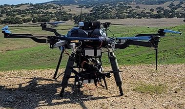
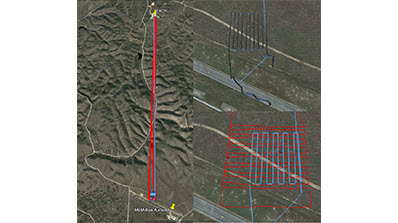
The Nevada National Security Site validated the concept at Camp Roberts with a beyond line-of-sight transit and aerial deployment in November 2021. The transport vehicle was a Harris H6 hexacopter, and it carried a 3DR Solo quadcopter (the Solo) three miles from the Combined Arms Collective Training Facility to the McMillan airstrip, deploying the Solo at an altitude of 100 meters above ground. The Solo was equipped with a small cadmium zinc telluride gamma detector, a volatile organic compound sensor and a range-finding lidar. The Harris H6 was similarly equipped, but it carried a larger 2”x2” sodium iodide gamma detector. After deployment, both aircraft flew survey patterns and transmitted data back to base in real time, along with the data from the Solo relayed by the Harris.
For this demonstration, the Solo was not brought back home by the Harris. It landed at the destination after transmitting its data back to base via the Harris. To avert mishaps during the remote landing, the Solo was configured with the option to hook up to two separate hand-held controllers: one at the launch site and the other at the landing site. The Solo could also be landed manually if necessary.
Web servers on both aircraft controlled the detectors and streamed data in real time. Real-time strip chart data of detector signals and situational telemetry (time-of-day, GPS coordinates, altitude, attitude, etc.) were monitored from base. Both aircraft were also able to stream real-time data into COPERS (Common Operating Picture for Event Response and Situational Awareness), successfully meeting another of the team’s objectives.