
Indirect Measurement of Underground Facility Expansion/Extent through the Multi-Modal Use of Cyber Metadata (Traceroutes) and Physics-Informed Models Applied to Pre-Post Digital Surface Mapping
Project #: 22-126 | Year 2 of 2
Daniel Champion,a Caleb Dahlke,b Jason Pacheco,c Jesse Adamsa
aMission Support and Test Services, LLC; bUniversity of Arizona, Department of Mathematics; cUniversity of Arizona, Department of Computer Science
Executive Summary
This SDRD project is developing analytic and inference methods that can be used to improve measurements for the size, expansion, and/or layout of underground facilities. These methods are intended for the challenge case where only indirect cyber, seismic, and photogrammetry data modalities are available to predict properties of an underground facility. The project has undertaken experiments in controlled conditions to assess the potential value for new measurement opportunities within each data modality, and, where possible, apply to real-world data. The new measurements are used in conjunction with a multi-modal inference capability based on Approximate Bayesian Computation Sequential Monte Carlo (ABC-SMC) to produce more informed estimates of underground facility properties.
Description
This project has focused on three modalities and corresponding indirect measurement opportunities. First, a cyber modality based developing high-resolution latency estimates from large quantities of traceroutes/Internet Control Message Protocol (ICMP) echo requests targeting a remote computer (presumably in an underground facility). Second, a seismic based modality using 3D localization of uncooperative seismic emitters observed using an array of surface geophones. Third, a geospatial intelligence (GEOINT) based modality using digital surface mapping (could use LIDAR or photogrammetry measurements as an input) to identify stochastic surface decay (subsidence) and infer tunnel parameters that are likely to explain the subsidence. These modalities and approaches provide potential pathways to measure tunnel length, topology, or size.
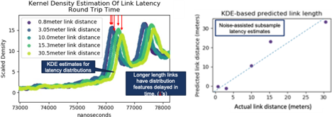
Experimentation using the cyber modality resulted in an ICMP-echo timing experimental design and analytic method that demonstrated latency timing with a resolution of 42.4 nanoseconds under controlled (laboratory) conditions. This amounts to a 24× improvement over the native clock resolution on the sensing computer and corresponds to a 4.2m resolution when used for distance/length measurement. Figure 1 shows the latency distributions, location features used by the analytic, and resulting length estimates for a range of network cable length configurations in an experiment conducted with ground truth.
Investigations into the seismic modality resulted in the application of a Bayesian multivariate change-point algorithm based on Fearnhead’s 2006 work. This allowed for the empirical estimation of propagation models for a limited number of seismic events created by an underground radiography instrument at the NNSS.
Much of the year two work focused on the measurement and inference capabilities associated to the GEOINT modality (subsidence, stochastic surface growth/decay). Starting with parametric subsidence models (Loganathan and Poulos 1998), a maximum a posterior inference capability was developed to recover tunnel parameters given a noisy observation of surface subsidence (e.g., photogrammetry or LIDAR based digital surface map).
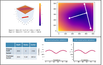
Tests on synthetic datasets with known ground truth showed the success and limitations of the method wherein parameter recovery is diminished with increased tunnel depth and reduced tunnel radius (Figure 2 upper left). Using prior distributions on the tunnel inputs (from other tunnel measurement modalities) improved performance and demonstrated the feasibility of multi-modal tunnel parameter inference. Because parametric subsidence models are not available for all applications, a non-parametric inference approach was developed based on a subsidence forward simulation capability (2D and 3D lattice spring models, Figure 2 upper right). 2D and 3D subsidence forward simulators were developed and provided to an ABC-SMC inference method (Bonassi and West 2015; see Figure 2 bottom). The ABC-SMC framework is compatible with putative samples obtained from a forward simulator and allows the simulator to be tailored to the local geophysics of each application.
Conclusion
Characterization of underground facilities will remain a challenge case for remote sensing, limited access, and far-field measurement. The work of this project helps identify pathways and opportunities to make advancements in measurements suited to this challenge case. Specifically, we demonstrated incremental progress in the development and inference upon multiple orthogonal underground facility characterizations and measurements. In all cases advancements were made by combining advanced analytic capabilities with low-fidelity or far-field data modalities to produce, extend, and enhance measurement.
Mission Benefit
The evaluation and remote sensing of underground facilities is a contemporary area of defense nuclear nonproliferation (DNN) research. The seismic modality analytic methods from this project have been merged with the seismic localization analytics used by the Advanced Data Analytics for Proliferation Detection (ADAPD) DOE DNN R&D programmatic research. Additionally, the Lattice Spring Model (LSM) based forward simulation and inference has shown the value of lower-fidelity surrogate forward simulators that enable high iteration counts and inference. The 3D LSM forward simulation capabilities and inference methods developed in this project are now being leveraged for use in Stockpile Science and momentum diagnostic research in partnership with Lawrence Livermore National Laboratory Design Physics.
References
Bonassi, F. V., M. West. 2015. “Sequential Monte Carlo with Adaptive Weights for Approximate Bayesian Computation.” Bayesian Anal. 10 (1) : 171-187. https://doi.org/10.1214/14-BA891.
Fearnhead, P. 2006. “Exact and Efficient Bayesian Inference for Multiple Changepoint Problems.” Statistics and Computing 16 (2): 203-213. https://doi.org/10.1007/s11222-006-8450-8.
Loganathan, N., H. G. Poulos. 1998. “Analytical Prediction for Tunneling-Induced Ground Movements in Clays.” Journal of Geotechnical and Geoenvironmental Engineering 124 (9): 846-856. https://doi.org/10.1061/(ASCE)1090-0241(1998)124:9(846).
This work was done by Mission Support and Test Services, LLC, under Contract No. DE-NA0003624 with the U.S. Department of Energy. DOE/NV/03624–1678.
Return to User-Centered Remote Testing and Operations
Go to SDRD Annual Report Index
Return to SDRD Homepage