
Determining the Seismic Hazard of Subsurface Facilities
Project #: 22-111 | Year 2 of 2
Michelle Scalise,a Arben Pitarka,b Cleat Zeiler,a Artie Rodgers,b Devon Smitha
aNevada National Security Site (NNSS); bLawrence Livermore National Laboratory
Executive Summary
This project uses high-performance computing and physics-based models to simulate ground motion of a magnitude 6.5 earthquake on the Yucca fault at the underground working level of critical facilities. Simulation results characterize the impact to critical facilities and improve resiliency in the event of strong seismic shaking.
Description
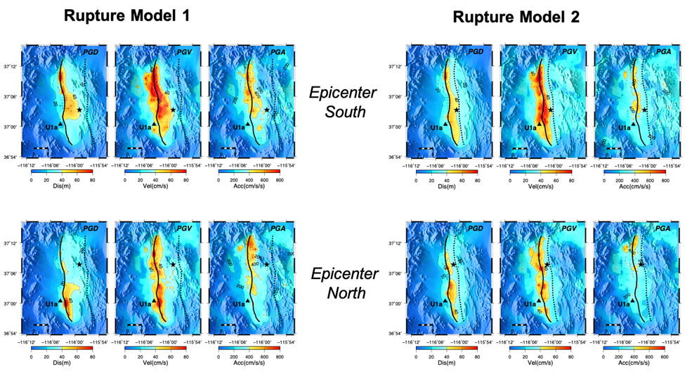
The NNSS is located in a seismically active region and is prone to strong seismic shaking resulting from large magnitude earthquakes. For this project, we used physics-based 3D waveform modeling and high-performance computing to deterministically simulate ground motion from a magnitude 6.5 earthquake on the Yucca fault at the NNSS site, approximately 50 miles northwest of Las Vegas, Nevada. These methods provided the capability to estimate seismic shaking at critical infrastructure such as U1a. Earlier work has simulated ground motion at the surface, but the working level of the facility is approximately 295 m below the ground surface. We developed new methods to calculate ground motion at depth and analyze the impact to the facility. Using the Geologic Framework Model, which is a 3D geologic model of Yucca Flat, we developed a 3D velocity model, incorporating geologic and geophysical data. Simulations were computed with rupture models using varying fault geometry and rupture initiation. A single simulation produces ground motion from one of many possible scenarios. For seismic hazard analysis, multiple deterministic simulations are necessary to capture the median and variability in ground motion at a site of interest. Results indicate that predictions of ground motion at U1a are sensitive to both the rupture initiation and fault geometry. Consistently in all simulations, there was strong ground motion near the surface fault trace, higher ground motion in the hanging wall, and strong amplification near the U1a facility due to a deep sedimentary pocket. The last year of the project focused on expanding the parameter space by varying rupture speed and statistical slip distribution along the fault plane, as well as adding small scale heterogeneity to the 3D velocity model. The 0–5 Hz broadband simulations were used to analyze ground motion along a vertical profile at U1a, approximating the ground motion along the elevator shafts. Fault normal permanent displacement was less than 0.3 m and maximum differential displacement was less than 0.15 m. Rupture properties and fault geometry produced greater variability in ground motion at U1a, whereas small scale heterogeneity in the velocity structure improved the high frequency character of the waveforms but had less effect on the permanent displacement.
Conclusion
We have demonstrated a successful methodology to perform ground motion estimates for seismic hazard analysis of underground critical infrastructure at the NNSS. The capability heavily relies on comprehensive 3D geologic models, available geophysical data, and high-performance computing resources. Using alternative fault geometries and rupture initiations, simulations have determined that U1a is located near an area of amplified ground motion. Results captured variability in ground motion due to fault geometry, rupture properties, and velocity structure. Permanent displacement at U1a is less than 0.3 m and provides an insight into the seismic effects to the facility, but integration with soil-structure-interaction codes can provide more refined estimates.
Mission Benefit
Having a methodology to quickly and efficiently model areas with critical infrastructure or potential testbeds is an important capability. This work will allow us to improve the accuracy of our strong ground motion predictions for future earthquakes and other seismic sources, and will help us develop measurements needed for protecting facilities located in areas with high seismic hazard. Models will provide information needed to protect valuable instrumentation that is critical to the facility from damage due to strong seismic shaking. Results support NNSS safety and resiliency. The methodologies described in this report can also be used to predict ground motion from underground explosions, and thus have the potential to advance detection capability of nuclear testing. The modeling can provide a template for future development and provide a tool for operational mission partners to better understand whether an unknown signal is natural or man-made. Having accurate models is a core capability for discriminating signals and for determining accurate locations and yields. Models that can accurately predict ground motion amplitudes provide critical information for determining more accurate yield estimates and locations of underground nuclear explosions.
Publications, Technology Abstracts, Presentations/Posters
Scalise, M. 2021. “Earthquake Location and Ground Motion Models.” Presentation presented at the Science & Technology Work in Progress Seminar, Las Vegas, NV.
This work was done by Mission Support and Test Services, LLC, under Contract No. DE-NA0003624 with the U.S. Department of Energy. DOE/NV/03624–1597.
Return to User-Centered Remote Testing and Operations
Go to SDRD Annual Report Index
Return to SDRD Homepage